Pelorus Bridge (A18)

Pelorus Bridge DoC campground and scenic area, South Island New Zealand.

GPS: -41.298801° 173.572032°

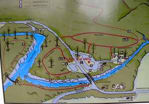
Carpark map of Pelorus Bridge area

Carpark map of Pelorus Bridge area

x

View from the Pelorus River highway bridge

View from the Pelorus River highway bridge

x

Swimmably warm Pelorus River, upstream of campground

Swimmably warm Pelorus River, upstream of campground

x

Pelorus Bridge diving

Pelorus Bridge diving

x

Jumping rocks at DoC Pelorus Bridge campground

Jumping rocks at DoC Pelorus Bridge campground

x

Open grassy camp area at Pelorus Bridge

Open grassy camp area at Pelorus Bridge

x

Pelorus River at DoC campground

Pelorus River at DoC campground

x

Doc Campground kitchen at Pelorus Bridge

Doc Campground kitchen at Pelorus Bridge

x

Bridge on a walking track at Pelorus Bridge

Bridge on a walking track at Pelorus Bridge

Bridge on a walking track at Pelorus Bridge.


One Response to “Pelorus Bridge (A18)”

  1. DGottschlich Says:

    Did you know, that there is a ~20min walk to a waterfall with hunded of glowworms? 😉

Leave a reply to DGottschlich Cancel reply